大型台風10号、沖縄近海北上 7日にかけ奄美や九州接近―特別警報級、安全確保を
大型で非常に強い台風10号は5日午前、沖縄県・南大東島の南海上を北西へ進んだ。猛烈な勢力に発達して6日未明に南大東島、6日午後に奄美大島に接近。7日午前にかけ、特別警報級の勢力を維持したまま九州の西部に接近、上陸して縦断するか、西岸近くを朝鮮半島に向かって北上する見込み。
気象庁の杉本悟史主任予報官は「進路予想の範囲が狭くなり、重大な災害が起きる確度が高くなった」と説明。記録的な暴風や高波、高潮のほか、大雨による土砂災害、河川の氾濫、浸水に最大級の警戒をするよう呼び掛けた。風雨が強まる前に、早めの避難、安全確保が必要という。
10号は5日午前11時、南大東島の南南東約190キロの海上を時速15キロで北西へ進んだ。中心気圧は920ヘクトパスカル、最大風速50メートル、最大瞬間風速70メートル。東側280キロ以内と西側220キロ以内が風速25メートル以上の暴風域、東側600キロ以内と西側440キロ以内が風速15メートル以上の強風域。
6日にかけて予想される最大瞬間風速は沖縄と奄美が80メートルで、弱い建物が倒壊するレベル。九州南部は65メートル、九州北部35メートル、四国30メートル。海上はうねりを伴う猛烈なしけになり、波の高さは沖縄・奄美と九州南部14メートル、九州北部と四国9メートル、近畿と東海6メートル。
6日正午までの24時間予想雨量は多い所で、沖縄300ミリ、奄美150ミリ、九州南部と関東甲信100ミリ、九州北部と近畿、東海80ミリ。
その後、7日正午までの24時間予想雨量は、九州南部400~600ミリ、九州北部と四国300~500ミリ、奄美と東海300~400ミリ、近畿200~300ミリ、沖縄と関東甲信100~150ミリ、中国50~100ミリ。8日正午までの同雨量は、東海300~500ミリ、四国と関東甲信200~300ミリ、九州北部と中国、近畿100~200ミリ、九州南部100~150ミリ。(2020/09/05-12:32)


Strong Typhoon Heading toward Southern Japan Islands
A very powerful typhoon is expected to head toward a chain of islands in southwestern Japan on Sunday and threaten to slam into the Kyushu region the following day.
Typhoon Haishen, the 10th typhoon of the year, is forecast to approach Minamidaito Island in Okinawa Prefecture in the early hours of Sunday and Amami-Oshima Island in Kagoshima Prefecture on Sunday afternoon.
While remaining so strong as to prompt a possible emergency warning, the typhoon is expected on Monday to either make landfall in the western coast of Kyushu or travel north off the coast toward the Korean Peninsula.
The Japan Meteorological Agency urged residents on Saturday to be on maximum alert for strong winds, high waves, high tides, heavy rains, landslides and flooding.
As of 9 a.m. Saturday (midnight Friday GMT), the typhoon was traveling northwest at a speed of 15 kilometers per hour at a point about 220 kilometers south-southeast of Minamidaito Island.
最新ニュース
-
靖国神社落書き、認める=中国籍男、石柱に「トイレ」―東京地裁
-
円急伸、一時149円台=利上げ観測で1カ月ぶり
-
中谷防衛相、オスプレイ「安全確保に万全」
-
円相場、150円12~14銭=29日正午現在
-
ヘルナンデス残留=プロ野球・ソフトバンク
写真特集
-
【野球】慶応大の4番打者・清原正吾
-
【競馬】女性騎手・藤田菜七子
-
日本人メダリスト〔パリパラリンピック〕
-
【近代五種】佐藤大宗〔パリ五輪〕
-
【アーティスティックスイミング】日本代表〔パリ五輪〕
-
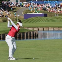
【ゴルフ】山下美夢有〔パリ五輪〕
-
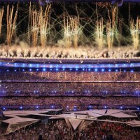
閉会式〔パリ五輪〕
-
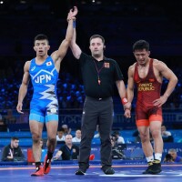
レスリング〔パリ五輪〕